
Understanding the Winter Weather Advisory: Snow, Sleet, and Ice Threaten Slick Roads Across the Region
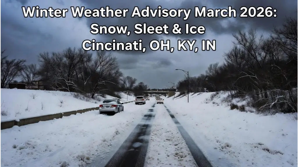
Winter Weather Advisory: Winter weather often arrives with little warning, turning familiar roads into slippery hazards and disrupting daily life. On March 2, 2026, the National Weather Service in Wilmington issued a winter weather advisory warning of a messy mix of snow, sleet, and ice that could make roads slick, especially during the morning commute. The advisory covers Southwest Ohio (including Cincinnati), Northern Kentucky, and Southeast Indiana, with ripple effects felt across parts of the Mid-Atlantic and Northeast as a transitional system moves through.
Winter Weather Advisory
A winter weather advisory signals that conditions will cause significant travel inconveniences and hazards, though not as severe as a full winter storm warning (which typically requires heavier accumulations like over a quarter-inch of ice or several inches of snow). In this case, the focus is on light snow and sleet up to about 1 inch total, with ice up to a tenth of an inch—enough to glaze roads, bridges, and overpasses. These alerts are vital public safety tools, giving people time to prepare, adjust travel plans, or stay home if needed.
This event follows a pattern of volatile early March weather. After a historic late-February blizzard dumped heavy snow in parts of the Northeast, this fast-moving system brings another round of wintry precipitation before a shift to warmer, wetter conditions. This post explores every detail: the advisory specifics, precipitation science, regional impacts (especially in the Cincinnati Tri-State area), preparation tips, and what comes next.
Current Winter Weather Advisories: Timing, Location, and Expected Conditions
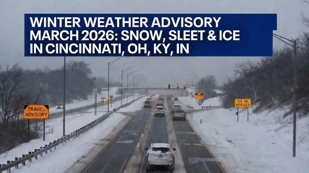
The NWS Wilmington office issued the winter weather advisory effective from 3 a.m. to 11 a.m. EST on Monday, March 2, 2026, targeting Southwest Ohio, Northern Kentucky, and Southeast Indiana. A messy mix of snow, sleet, and ice accumulations is possible across the region Monday morning.
Total accumulations: Snow and sleet up to 1 inch (with isolated higher spots), and ice up to 0.1 inch (a light glaze). The advisory explicitly warns: “Roads, and especially bridges and overpasses, will likely become slick and hazardous. Plan on slippery road conditions. The hazardous conditions could impact the Monday morning commute.”
Timing of the wintry mix:
- 4-6 a.m.: The system moves in from the west, bringing primarily snow to most areas. Closer to and south of the Ohio River, a quicker transition to sleet occurs around daybreak.
- Mid- to late morning: Farther north of the river, several hours of light to moderate snow are expected. Counties near the Ohio River in Northern Kentucky, southern Ohio, and southeast Indiana could see up to 0.1 inch of ice, sufficient for slick roads and elevated surface glazing.
- Early afternoon: Temperatures slowly climb, and most lingering precipitation changes to plain rain by early afternoon.
In Cincinnati specifically, the forecast calls for rain, snow, freezing rain, and sleet before 1 p.m., then a chance of rain. High near 37°F, east winds around 7 mph, and 100% precipitation chance. Little or no ice accumulation is expected overall, with new snow and sleet less than a half inch.
Schools across the region have responded with delays and closings, reflecting the potential for hazardous morning travel. The advisory ends at 11 a.m., but slick spots may linger briefly on untreated surfaces.
The Science Behind Snow, Sleet, and Ice
Understanding why this storm produces a “messy mix” requires looking at atmospheric layers and temperature profiles.
Snow occurs when the air column from cloud level to the ground stays below freezing (32°F/0°C). Moisture freezes into ice crystals that grow into snowflakes. In this event, initial cold air supports snow, especially north of the Ohio River.
Sleet forms when snow melts in a shallow warm layer aloft, then refreezes in a cold surface layer into small ice pellets that bounce on impact. This is common in transitional zones near the river, creating a crunchy, slippery layer.
Freezing rain (the most dangerous) happens when snow fully melts in a warm layer, becoming liquid rain that falls into subfreezing air near the ground. Droplets supercool and freeze instantly on contact with surfaces, forming a clear, slick glaze. Even 0.1 inch can coat roads, bridges, and power lines, leading to black ice—nearly invisible and extremely treacherous.
The storm’s dynamics involve lingering Arctic air clashing with a warm front pushing north, creating the perfect setup for mixed precipitation. Winds of 5–10 mph (with gusts higher) reduce visibility during heavier bursts.
What to Do During a Freeze Warning: A Complete Preparation and Protection Guide
Impacts on Roads, Travel, and Daily Life
The advisory’s core concern is slick roads. Snow reduces traction and obscures markings; sleet adds uneven texture; freezing rain creates black ice, especially on bridges and overpasses that cool fastest. Even light accumulations cause skids, longer stopping distances, and crashes.
In the Tri-State, the morning commute (roughly 6–9 a.m.) faces the highest risk, with many schools delaying or closing. Airports may see delays, and public transit could slow. Untreated surfaces remain hazardous briefly after precipitation ends.
Power outages are possible from ice on lines, though light accumulations limit widespread issues. Economically, winter events cost billions in lost productivity, repairs, and salt usage (which harms waterways long-term).
Preparation and Safety Tips for Residents
Preparation minimizes risks:
- Essentials: Stock food, water, medications, flashlights, batteries, and blankets.
- Home: Insulate pipes, keep thermostat at 55°F+ if away, and clear sidewalks promptly.
- Driving: Check tires (tread and pressure), use winter tires if possible. Drive slowly, increase following distance (at least 8–10 seconds), avoid sudden moves. If skidding, steer gently into the direction and ease off brakes.
- Pedestrians: Wear sturdy, grippy boots; watch for black ice.
- Pets & Vulnerable: Limit outdoor time for animals and check on elderly/neighbors.
Fox News Live Stream – Watch Free 24/7 Coverage Online
The Shift to a Warm, Wet Pattern
After Monday’s wintry mix, the region enters a warmer, wetter stretch through the week. From Tuesday onward, occasional rain—possibly with thunderstorms—moves through Tuesday through Saturday. Repetitive rainfall raises flooding concerns, especially in low-lying areas or with saturated ground.
Cincinnati’s extended forecast:
- Tuesday: Rain, patchy fog, high near 60°F, 90% chance.
- Tuesday night: Rain, low 53°F, 80% chance.
- Wednesday: Rain likely with possible thunderstorms, high near 68°F, 70% chance.
- Thursday: Rain, high near 70°F, 80% chance.
- Friday: Chance of rain, high near 76°F, 50% chance.
- Saturday: Rain, high near 75°F, 80% chance.
- Sunday: Chance of rain, high near 66°F, 40% chance.
This pattern signals a classic early March transition: lingering winter threats give way to spring-like warmth and moisture.
How to Stay Informed and What to Expect Next
Stay updated via NWS Wilmington alerts, local TV/radio, or weather apps. Forecasts can shift, so check frequently.
Post-Monday, expect rapid melting of any snow/ice as temperatures rise. The warm, wet week increases flood potential—avoid driving through standing water and monitor rivers/streams.
Conclusion
This March 2, 2026, advisory underscores winter’s lingering grip on the region. A quick, light wintry mix threatens slick roads and morning commutes in Southwest Ohio, Northern Kentucky, and Southeast Indiana—but the impacts should be short-lived as warmer, rainier weather takes over. By understanding the science, heeding warnings, and preparing ahead, residents can stay safe and minimize disruptions. Spring is on the horizon—stay informed, drive cautiously, and embrace the seasonal shift.